An active threat can occur anywhere, at any time, and without warning. Unfortunately, active threats can endanger not only the lives of those directly involved, but also the lives of innocent bystanders and emergency service personnel responding to the scene. An active threat can also result in significant and costly property destruction.
Although we may never be able to predict future emergencies, we can and should take steps to prepare our first response teams for critical situations. Providing consistent, thorough training for high-risk scenarios, active threats, and other emergency response situations is well worth the time and investment for fire departments and first responders.
OSCR360 can assist with active threat and emergency response training
Firefighters routinely find themselves entering first response situations blindly, not knowing what might be in store for them when they respond to a call. Unfortunately, it isn’t logistically possible for every firefighter to physically tour and train within every public space or high-risk environment. Yet, imagine if every firefighter on the force had virtual access to each place of public assembly in their district, including schools, hospitals, government buildings, theaters, hotels, bars/restaurants, clubs, and office spaces.
OSCR360 provides a valuable look inside public spaces so that firefighters can familiarize themselves with a building’s layout, virtually, prior to future emergency situations.

Schedule active threat and emergency response training at your fire department & during down time
Using OSCR360 means that training can take place anywhere, anytime. This means that firefighters can virtually access high-risk public spaces without ever leaving headquarters. Whether trainings are planned, or happen during downtime, OSCR360 is a convenient and highly effective way to walk every firefighter through every public space in your community. Train on the layout and evacuation strategies, as well as make threat assessments.
In-house training with OSCR360 can aid in:
- Improving response times, as well as the quality and effectiveness of response
- Preventing injuries and limiting safety risks for first responders
- Increasing situational awareness by having a general idea of what the scene looks like
- Better care for the victims at the scene by understanding the risks and escape routes

Document all public spaces to prepare for an active threat
Fire departments have some opportunity to familiarize themselves with public spaces while conducting building inspections, but only a fraction of the force is present for the inspection. As these inspections are typically conducted annually, and the focus of inspections is identifying fire code infractions, the inspection itself is not the ideal time for training within that space.
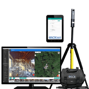
Instead, bring OSCR360 along to every inspection and document information along the way. Each image requires only a few seconds to capture and will be part of your OSCR360 project to be accessed on-demand later for training and review.
Document where and how a fire could potentially start, as well as emergency access routes into and out of the building, all within the OSCR360 project. Flag any locations that failed inspection and add applicable comments to explain the infraction.
Incorporate blueprints and pertinent building notes within OSCR360
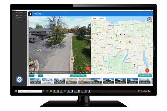
Use OSCR360’s Point-of-Interest feature within the Desktop Software to notate the location of any notable emergency equipment including:
- AEDs.
- Hydrant access.
- Smoke/Fire alarm positioning.
- Security cameras.
- Locations and types of fire extinguishers on the premises.
- The whereabouts of fire doors.
- Notating doors that are kept locked/unlocked.
- Stairwells.
- Elevators.
- Areas that may contain populations in need of extra assistance.

Pinpoint any areas with potential hazards, such as gas pumps, chemical storage, computer server rooms, boiler room, electrical rooms, flammable or combustible materials, and kitchens. Incorporate building blueprints and maps into any OSCR360 project, as well. This gives you a complete understanding of a space, in order to create a more succinct emergency plan.
Allow response teams to communicate effectively
During an active threat, command staff on the outside can clearly communicate with first responders on the inside by having the advantage of knowing the building layout.
Understand where first responders are in the building by following along within the OSCR360 project. Inform first responders about environmental hazards that may be present. Additionally, OSCR360 virtual walkthroughs can be uploaded and shared on all of the MDTs in the department, so firefighters can access a building virtually for review while in route to a live scene.

Share OSCR360 projects with other agencies
Active threat situations can occur in a variety of environments, and often require involvement from multiple agencies. For example, locations that house dangerous chemicals, school buildings, areas prone to inclement weather or flooding, all have the potential for a future active threat situation. OSCR360 projects can be shared with other parties, such as law enforcement, school staff, local government, EMS, and more for a collaborative approach. There is a viewer-only version of the software that other agencies can use to access the OSCR360 projects that you choose to share.
Countless other purposes
The opportunities are as limitless as the imagination with OSCR360. For instance, several agencies are using OSCR360 to document and investigate crash scenes and fire scenes. Some agencies are partnering with local school districts to create emergency response plans. Others are capturing environments post-incident and using these OSCR360 presentations to review responses and what could be improved next time. Some departments are sharing their OSCR360 projects with insurance companies or district attorneys for prosecution purposes.
And some agencies are using OSCR360 for all of the above, and more!
Additional information on OSCR360
- OSCR360 requires limited manpower. Document any location with only one person.
- OSCR360 images are spherical, meaning that you can view the image in 360 degrees, floor to ceiling, with virtually no blind spots.
- Each image takes seconds to capture.
- Using HDR-mode will ensure the highest quality photos in dark spaces.
- OSCR360 is user-friendly, even for those who are not tech-savvy. Just ask the hundreds of public safety agencies nationwide who have already incorporated OSCR360 into their day-to-day operations.
- For large spaces or environments with multiple rooms/floors, connect your images sequentially in OSCR360’s software to create a virtual walkthrough of the environment.
- Within the OSCR360 desktop software, precisely note any areas of interest, such as hazardous chemical storage, AED locations, exit doors, and more.
- Access OSCR360 projects from any desktop, tablet, or MDT by downloading the free OSCR360 viewer.
Check out the additional resources below, or contact the L-Tron team to see more about how your department can use OSCR360 for active threat and emergency response training.